Books
Magazines
Artwork
Editions
Multimedia
Allied Publishers
Authors
Style
Perla Medley
Posters & Postcards
Antiquarian
Catalogued in Koeman IV, map 588, ed. 41:1-3 (1588 B&H 4), Nebehay-Wagner 108/44.
The work is in the collections of the GMB in Bratislava under inventory number C_19818.
In the collections of the GMB in Bratislava under inventory number C_7766.
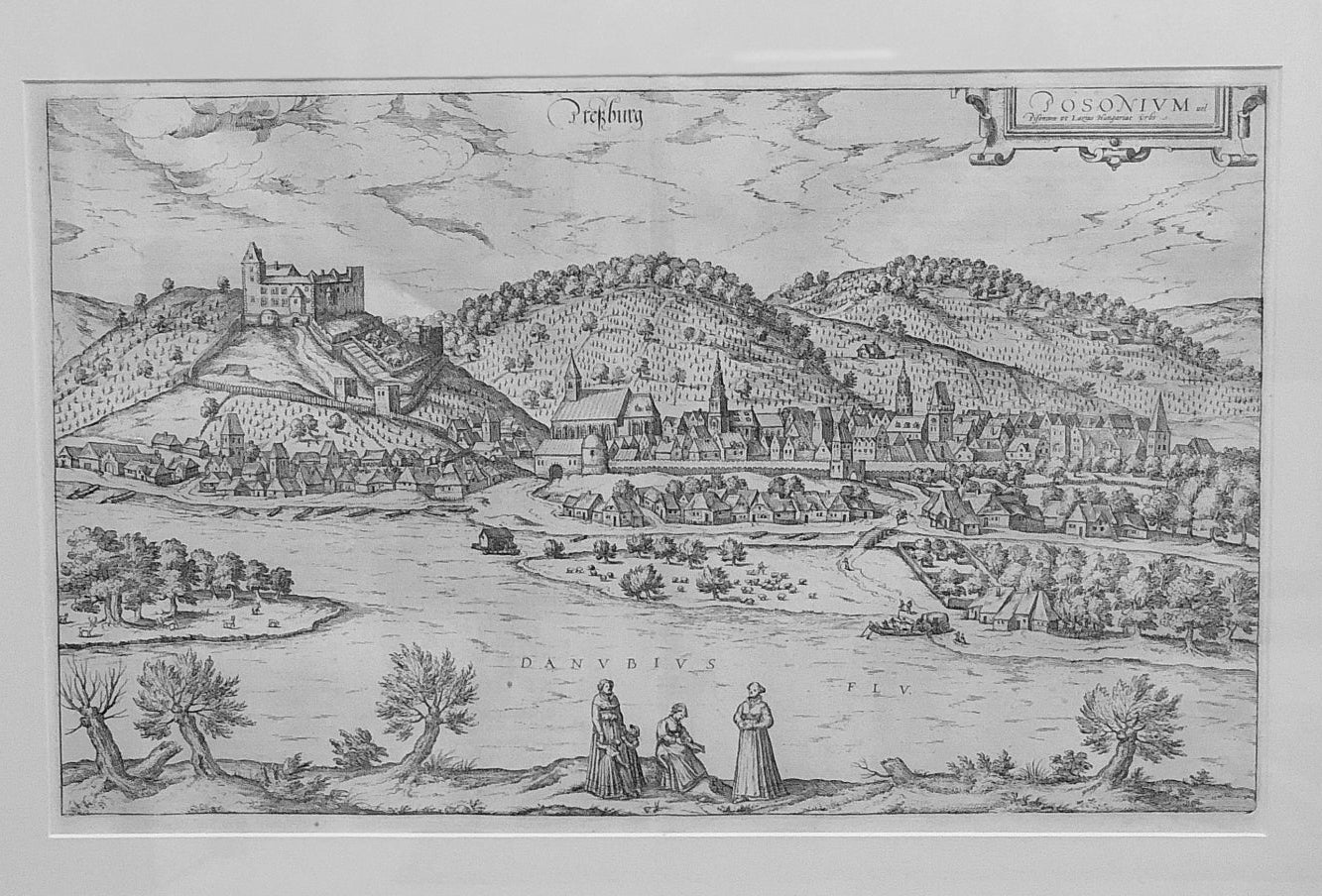
BRAUN'S COMMENT (on the back): "This is an old and beautiful city, which is much better than all other Austrian cities, not only because of its fortunate location, but also because of the way of life in it and its invigorating climate. It is surrounded by hills covered with vineyards and many forests. Therefore, the sun does not allow the wine to become too sweet. Near the outskirts, there is a castle on a high hill that defends the city from enemies and ensures its protection. It continues to respect and honor its lawful rulers. Below it, the famous Danube River flows through green meadows, gardens, and pastures where flocks of sheep, chamois, deer, and other game can be seen grazing.
It is a view from a high vantage point looking south towards the city on the north bank of the Danube, with the Little Carpathians towering in the background. On the left is a castle on a hill with the city at its foot. St. Martin's Cathedral, whose tower is depicted on a disproportionately small scale, is located on the western edge of the lightly fortified city. Bratislava (German: Pressburg) belonged to the Kingdom of Hungary almost continuously from the beginning of the 10th century until 1918. A market town grew up below the old castle, and in 1241 numerous German colonists settled here. After a large part of Hungarian territory and its capital, Buda (Ofen), fell to the Ottomans in 1526, Bratislava was used as the capital city until the 18th century. The Hungarian Habsburgs were crowned in St. Martin's Cathedral between 1563 and 1830. In 1918, Bratislava was transferred to the new Czechoslovak Republic; since 1993, it has been the capital city of Slovakia.
Braun G. and Hogenberg F. and Civitates Orbis Terrarum.
Civitates Orbis Terrarum "Braun & Hogenberg" is a six-volume city atlas and the largest book of city views and plans ever published: 363 engravings, some beautifully colored. It was one of the best-selling works of the last quarter of the 16th century. Georg Braun wrote the text that accompanied the plans. A large number of views were engraved based on original drawings by Joris Hoefnagel (1542–1600), who was a professional artist. The first volume was published in Latin in 1572, the sixth volume in 1617. Frans Hogenberg created the plates for volumes I to IV and Simon van den Neuwel for volumes V and VI. Other contributors included cartographers Daniel Freese and Heinrich Rantzau. Works by Jacob van Deventer, Sebastian Münster, and Johannes Stumpf were also used. Translations were published in German and French.
After the original publication of Volume 1 of the Civic Associations in 1572, seven further editions can be identified from 1575, 1577, 1582, 1588, 1593, 1599, and 1612. Volume 2, first published in 1575, was followed by further editions in 1597 and 1612. Further volumes appeared in 1581, 1588, 1593, 1599, and 1606. A German translation of the first volume appeared in 1574, and a French edition followed in 1575.
Several printers were involved: Theodor Graminaeus, Heinrich von Aich, Gottfried von Kempen, Johannis Sinniger, Bertram Buchholtz, and Peter von Brachel, all of whom worked in Cologne.